- Home
- Overview
- About Us
- Routes
- A-Around Blaenavon Routes
- B- Gwent Valley Routes
- C-Around Abercarm
- D- North of Pontyrpidd
- E- South of Pontypridd
- F- West of Pontypridd
- G- Around Caerphilly
- H- Around Merthyr
- J- Bwlch & Rhigos Routes
- K- Neath & Glyncorrwg
- L-Black Mountains
- M- Llantrisant area
- N- Port Talbot & Swansea
- O- Brecon Beacons
- P- West Wales
- Q- Mid Wales
- R- around Llandovery
- S- Mynydd Epynt
- T- Train and Bike
- U- Welsh Borders.
M1- Llantrisant forest to Blackmill.

Grade- Easy but long.
Distance. 27.5 kms
Highlights. Wonderful views over the channel.
Start point. Follow the A473 through Llantrisant and Talbot green. At the last roundabout take the lane signposted Lanelay Hall, go past this for 2 miles and find a large Car park on the Left in Llantrisant forest (known locally as the Smylog).

Route. From the car park take the main forest road around the barrier and keep going straight ahead up hill. Avoid the first main turn on the Left, and keep going up hill around a bend, then down for a short stretch and meet a T junction. Go Left uphill for a few hundred yards to a pedestrian gate leading up a rocky path with the forest on your right and a field on your left. At the top of this is another pedestrian gate leading onto a good farm track.

Take this left- along the track of “a dozen gates” Keep on this track which stays just to the Right of the top of the ridge for about 4 miles. At one point where there is a gate into a field straight in front of you, turn Left then after 20 yards take the lane on the Right. Continue between the wind turbines until you come to the final gate leading up onto the open common of Mynydd Maendy. Near the top of this is a footpath on the Left, which takes you around Ty’n Y Cwm. Follow this until you come to the wall around a field, then follow this wall over the ridge and drop down to Cadairfach where you meet the mountain road coming up from Rhiwceilog.

Take this up hill past Coedcae farm, then take the grassy trail on the Left which skirts around the mountain then drops down a stony track to Bryn Chwith. Here there is a steep stony track leading straight up Mynydd y Gaer. Zig Zag your way up sheep paths and 4WD tracks to the trig point at the top, and drink in the views all around. Zig zag back down the other side heading for the small patch of forestry at Gelli Feddgaer. At the very top tip of this forestry is a lovely grassy trail which contours across the North flank of Mynydd Y Gaer, and comes to a muddy cross roads with a deep valley on your Right

Cross over onto the next small hill named Waun Wen and do (an optional) 360 circuit by following the walls around the fields until you come back to the steep valley, which is now on your Left. At the point where the dry stone wall starts to go down the valley’s Left ridge, there is a lovely path following the line of the wall. At the point that the Wall comes to a right angle Left, follow the path left along this wall and continue until you come to a road. Turn Right down this road until you come to a junction, then continue Right until you come to the very bottom of the hill. Here there is a cattle grid on your right, leading along a lane signposted as cycle Route 4.

Follow this back until you get to Gelli’r Haidd, then follow the lane down to Thomastown. When you come into Thomas town, take the street on the Right- named Pembroke Street. At the end of this is a lovely path through the woods. Follow this for a couple of miles. At the second road you cross you need to turn Left down the hill for 20 yards, then pick up the footpath on your right through some more woods, until you come to a stile into a filed. Follow the grassy path across this field and over another stile back into Llantrisant woods. Keep on this track which leads directly back to the car park. The last 600 yards can get very overgrown in the summer.
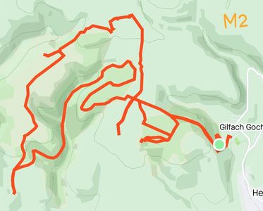
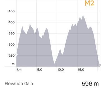
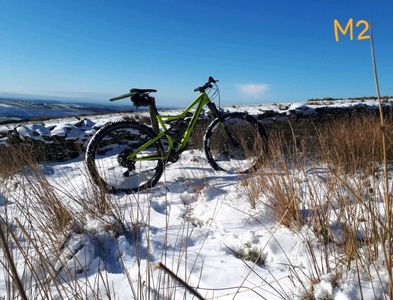
M2-gilfach goch, forestry and windmills
Grade- moderate- a couple of challenging climbs, with good forest roads most of the way.
Distance-20.6kms
Highlights.- Good quality Forest roads, some great views over other ridges.
Start point- Evanstown near Gilfach Goch.
Route- at the bottom of the furthest street on the Left of Evanstown, there is a track which leads up into the Mynydd Maendy forestry. We made a couple of circuits here, including a dead end which ends up at a terrific view point. We then crossed the ridge and dropped down into Ogmore Forest. Here we did a good circuit down Cwm Dimbath, back up over Mynydd yr Gwair and onto Craig Rhiwberfa, where there are some great views over Nant Y Mael and the Ogmore valley.
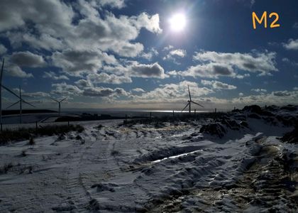
From here we took the new roads serving the wind generators and made our way back to Mynydd Maesteg, and dropping down Cwm Dyfylog back to Evanstown. We once did this in the snow, and since we were on Forest/windmill roads the whole way, it was was very safe, and even more fun!!.
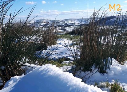
cycling in the snow gives a different perspective.
Dress well, take food and spare clothing, have good tyres..
M3- St Brides Major and coast around Southerndown

Grade-Easy, a few small hill climbs, mostly on good grassy tracks.
Distance- 19k, Ascent: 360m
Highlights.- Some amazing views over the River Ogmore and the coast.
Start point- . Parking area by cattle grid on the B4265 just at the start St Bride’s Major village (SS897752
Route- Take the small tarmac lane opposite to Ogmore Down. Bear right at the top and keep fence on your right as you cross the common. Head straight on into walled lane, down through gorse bushes and another walled lane to join main road where you turn left. In 0.5k, just past Pelican Inn, turn left towards Southerndown Golf Club. Where road bends right go straight ahead and follow bridleway signs across golf course. Turn right when you reach fence and sharp left at fence corner.
Look out for dry valley called Pant Mari Flanders on the right and head down this to main road. Cross road and bear left on coast path. Follow coast path via Ogmore rivermouth car park all the way to West Farm in Southerndown. Rejoin road for 200m then turn left toward Heol-y-Mynydd. Where road bends sharp right keep straight on over the common.
When you reach fence turn left and then sharp right at the fence corner. In 100m you reach a concealed farm gate in the corner. Go through and head down some lovely single track to reach the road in Pant St Bride’s. Head up the steep narrow path on the other side to top out on Old Castle Down. .
Bear right at the top and left after 100m onto a grassy path. In 500m bear right and look out for a way post where you bear left and head down to the Alun valley. Turn right and then right again at the crossroads. Follow the tarmac back to St Bride’s.