- Home
- Overview
- About Us
- Routes
- A-Around Blaenavon Routes
- B- Gwent Valley Routes
- C-Around Abercarm
- D- North of Pontyrpidd
- E- South of Pontypridd
- F- West of Pontypridd
- G- Around Caerphilly
- H- Around Merthyr
- J- Bwlch & Rhigos Routes
- K- Neath & Glyncorrwg
- L-Black Mountains
- M- Llantrisant and Vale
- N- Port Talbot & Swansea
- O- Brecon Beacons
- P- West Wales
- Q- Mid Wales
- R- around Llandovery
- S- Mynydd Epynt
- T- Train and Bike
- U- Welsh Borders.
N1- Bryn, blue Lake & Green Pool, margam forest
.JPG/:/cr=t:0%25,l:0.12%25,w:99.75%25,h:100%25/rs=w:1209,h:909,cg:true)
Grade- hard-Undulating forest roads, with one long hard climb back.
Distance- 29.2 KM
Highlights- Some of the most picturesque Forest lakes and pools you will ever find.
Start point- Lay-by on the B4282 between Maesteg and Bryn

Route- from the Lay-by follow the track adjacent to the golf course and climb up into the forestry. Here there are an abundance of tracks in all directions for you to explore. We dropped down the track s into Nant Y Glo Fach valley, dropped down a shorp steep slope to the Cwmwernder Reservoir (the blue lake) skirted the reservoir on a muddy footpath, then climbed up the other side of Cwm Nant Glo.

At the top we turned Right and carried on going over Ergyd Uchaf, then dropping down into Llan Ton Y Groes into Cwm Y Brombi. Here there is the most amazing green Pool (stained by Copper). Drop down into Brombil, then go under the M4 and take the road Left out of Margam, towards Margam Park. Just before this, take the lane beside the lake to the ruins of the Abbey. Take the track up Nant Cwm Phillip and cl;imb back up to Rhyd Blaen Y Cwm. From here is a straight forest road back to the start point.
%20Jly19%20IMG_2368%20(2).JPG/:/cr=t:0%25,l:0.12%25,w:99.75%25,h:100%25/rs=w:1209,h:909,cg:true)
The green pool.
%20Jly19%20IMG_2368%20(1).JPG/:/cr=t:0%25,l:0.12%25,w:99.75%25,h:100%25/rs=w:1209,h:909,cg:true)
.
N2-margam forest East

Grade- Moderate- several medium climbs, good tracks throughout.
Distance- 29.2 KM
Highlights- Some lovely views over Margam castle and the Severn Estuary. Wonderful Rhododendron forest in May/ June. Good chance of seeing Deer.
Start point- The duck pond by the side of the Celtic stones museum to the West of Margam Park.
Route- Head up the road from the duckpond then almost immediately take the bike path on your Right. Go through a rather large gate, turn Left, then bear Right up hill. Keep zig zagging upwards and to the Right until you get to the top where there is a large standing stone with "bro" carved into it. Continue along this track along the ridge with fine views over the Severn channel. There is a good chance of seeing deer here.
Go through another cycle gate, then follow the tracks upwards and to the Right until you leave the fields behind and come out onto open moorland. Here you come to a cross roads, with a cattle grid on the Left leading into the forestry. Take the Right turn and follow this road down the West side of Cwm Cynffig. This is a stunning valley. Continue until you come to a gate. Do not go through the gate, but take one of the very steep downhill tracks on your Left down to a small stream.
On the other side of the stream follow the track Left until it becomes a forestry road, then continue back up the East side of Cwm Cynffig to the very top where you come to a T junction. Turn Right and shortly you come to a tarmac road (which leads to Waun Y Gilfach). Go straight across this road into the Craig Yr Aber Forestry. Take the Left hand fok down the Left hand side of this valley until you come to another Tarmac road
Retrace your steps back about 200 yards and you will see a steep single track on your Left. Go up this and shortly it turns into a good forest road which zig zags back up the other side of Craig Yr Aber Forest. Continue back to the road (which heads towards Waun Y Gilfach) and go straight across back onto the forest road you came along. This time continue straight on this road until you come to the cross roads with the cattle grid leading into the forest , this time on your Right.
Take this road into the forest and almost immediately turn Left. Follow this down another valley until you come to a gate at the end of the forest. Go through the gate onto open moorland, and bear Right until you come to tracks leading back to the start. There is an option here of taking a single track red route back to the main gate.
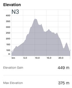
N3-felindre, two reservoirs, west
Grade- hard- Some hard climbs up gravel paths., then soft off road tracks over the mountains.
Distance- 25.2 KM
Highlights-two stunning reservoirs, , then some great views over the Bristol channel.
Start Point- Felindre village just North of J$^ of the M4
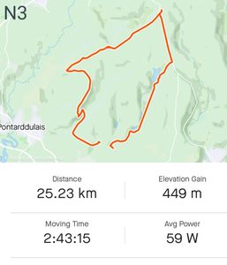
Route- take the street on the Right climbing out of Felindre by the school. As you come to the end of the houses, take a path on the Right leading up to the Lower Lliw reservoir. Cross the dam and take the road Left up the Right side of the reservoir.
Keep going up a wonderful valley until you get to Upper Lliw Reservoir. There is a path on the right through Brynllefrith woods which leads on to a mountain road. Take this Left, and climb the long hill until you get to the very top.
It is worth taking a short detour to see Penller Catell- an old Celtic Hill Fort taken over by the Normans. Back on the road, take the path on the Left to Pentwyn Mawr, then keep on to Graig Fawr, for some wonderful views over the Bristol Channel. Find some sheep tracks heading South over Twyn Tyle, and continue on to Cefn Drum.
. Drop down steeply on the Left into Cwm Dulais, then climb the road slanting back up the other side to the crossroads on Bryn Bach common. Take the road straight ahead back to Felindre. Give customers a reason to do business with you.
N4-POntardawe/ Mynydd Ally yr Grug

Grade- moderate- some lovely bike trails. One hard climb., then soft off road tracks over the mountains.
Distance- 22.2 KM
Highlights- a lovely bike trail along a canal, then some fantastic tracks across the top of a stunning mountain.
Start Point-Trading estate , on the Right just as you cross the bridge from Alltwen.
ROUTE. Park on the main road through the trading estate. Cycle to the end of this road and go through a cycle gate. Follow the cycle path to a fork. Take the Left Fork, then take a gravel track on the left to join the canal path. This is St Illtyds way. Follow this lovely path to Cilmaengwyn, Find Cwndu road, then take a Left off up Maengwyn lane. This is a great hill climb!
Keep going past Cilmaengwyn farm into the forestry, then take the gate on your right along a muddy track with several metal bridges. It gets better.! Shortly the track begins to climb onto the open mountain with stunning views. Just as the track starts to descend, you come to a fork. Turn Right up the hill, then take the next right up a very steep track to a gate. From here follow the single track trails until you come to a view point with a bench. From here is a short steep climb on the Right to the very top of the ridge.
On the top is Mountain Biking wonderland. There are a series of 4WD trails winding in circles over the whole of the top of the ridge, with stunning views in all directions. Spend as much time as you like playing around and getting lost Getting out of the forest again is tricky, since there are many dead ends. The easiest is to go back to the original fok and take the down hill track down to a tarmac road.
.
Follow this in the direction of Cwm Twrch Isaf, then take the road on the Right leading down to the old Clun Gwyn tip. Again stay to play as long as you can here, then take the main A4067 road into Ystalafera. At the main roundabout there is a cycle trail which takes you along another wonderful path all the way back to the trading estate in Pontardawe.
N5- Swansea Bay and Clyde valley
Grade- Easy- this is one of our easiest routes since it is mainly on the flat. There is one optional extra section which is for experienced riders only.
Distance- 25.2 KM
Highlights-Wonderful views all around Swanea Bay. Some challenging optional single track sections
Start Point- Briton Ferry
ROUTE- As you enter Briton Ferry, park on the main road by the first row of house you come to . 50 yards down the road is a bridge over an old canal. Just to the Left of this bridge is the start of a delightful cycle trail which firstly follows the canal, then crosses the main Road by a cycle bridge into Swansea Docks. continue on the cycle route over the bridge to the West Docks, then along the coast of Swansea Bay.
After about 3 miles cross the main road on your Right and go through the grand entrance into Singleton Park. There are loads of trails to chose from but if you keep going uphill to the Left, behind the University and the Hospital and come to a roundabout . From this a lane called Cwm Farm lane leads down back to the main road (Mumbles Road). Follow the bike trail along this for a few hundred yards to Black Pill car park
From this car park is a lovely family bike trail following the Clyde Valley, which you can follow all the way to Dunvant. For the more adventurous there is a gruelling single track climb on the Left up to Keepers Lodge. From here there are some challenging downhill tracks back down to the Clyne River. If you take the tracks along the river inland, you come out near the Railway Inn. Following the valley back down towards the sea, there are some lovely trails on the Left past the old brick works.
When you get back to the beach, follow the bike trail around Swansea Bay to the Mumbles pier, where there are some lovely cafes to stop for a drink or a snack. To get back to the car you will need to follow the Swansea Bay Cycle track all the way back to Briton Ferry.
N6- Hills of the Gower

GRADE-HARD- a long ride with several long off road climbs, but totally rewarding.
Distance- 44.3kms
HIGHLIGHTS- One of the best rides ever! 3 amazing ridges , each with fabulous views. Great paths.
START POINT. Car park in Penmaen just off the main road, on the Right).

ROUTE from the car park there is a track leading straight up the hill and along the ridge to Cefn Bryn. Follow this track for 2 miles along the ridge to the road, then take a short detour to see Arthur's stone- an ancient Celtic Dolmen. Take the track down to Hillend farm, then from here take the quiet lane past fairy hill hotel to the junction at Stembridge, turn sharp Left up the hill, then after 20 yards take the track on the Right along the base of Ryer's Down, and come out on the road heading into Llanmadoc.

Just as you come into Llanmadoc there is a lane on the Left, which leads into a track heading back Southeast climbing steadily up to stormy castle. From here there is a wonderful track up to the Trig point and along the ridge of Llanmadoc hill, with spectacular views in all directions. At the far end of the ridge drop down a steep path then skirt Left around the base of Llanmadoc Hill until you come to the road leading down into Llangennith. Take the
road on the left which turns into a steep rough track up to Coety Green. Take tracks on the Right to Barraston, and follow the tracks around the hill towards Hillend caravan park.

From here there is a track which heads along the fence line following the Wales Coast Path to the Old Rectory, and onwards to Rhossili. It is well worth taking a short detour along the coast path to see Worm's head. From Rhossilli take the road to Middleton, turn Left until you meet the Gower Way path climbing up the hill on your Left. Follow this to the top of Rhossili Down, where there is the most magnificent ridge ride back up overlooking Rhossili Bay. Follow this to the far end, then take the track dropping off on the Right towards Bessie's meadow.

From here there is a track heading South around the base of Rhossili Down. This joins up again with the Gower way at Fernhill Farm. Follow the Gower Way back Llandewi to Knelston and on to Reynoldston. Here it climbs climbs back onto the ridge of Cefn Bryn and back to the car park at Penmaen. Wow, what a ride!!

This is the classic vista of Rhossili beach .
N7- Brynamman, Carreg Cennin castle

GRADE-moderate- one long gentle climb up mountain roads
Distance- 28kms
HIGHLIGHTS-some lovely bike trails along the Amman valley. Fantastic views over Carreg Cennin. Wild landscape in the Carmathen Fans.
START POINT. Brynamman rugby pitch.

ROUTE Park in the lane leading to Brynamman rugby pitch. The Amman valley Bike Trail starts at the far end of the rugby pitch, and continues for 6 miles down the lovely Amman valley. As you approach Ammanford, you come to High Street. Turn Right here, then take the first right up the hill named Wen Ddu Rood. In about a mile there is a lane on the Right named Heol Ddu. There is a long, gentle climb to a cross road. Go straight ahead at this junction onto the open moorland of the Carmarthen fans.

Go straight ahead at the next cross roads also, and you are rewarded with some wonderful views of Carreg Cennen castle on the other side of the ravine. Keep climbing to the highest point on this road, and just before it goes downhill to the cattle grid at Wernwgn there is a grassy trail on your right which follows the contours of the mountain and brings you out on the mountain road at Brest Cwm Llwyd. Just up the hill is a car park on the Left. Opposite this is a grassy track heading up the mountain.

after a short while there is a junction, where you can either turn left back onto the road, then take the A4069 down the most delightful down hill all the way back to Brynamman, or if you are feeling adventurous, take the track on the right and carry on winding up the hill where it crosses the ridge, and drops down the other side into Brynamman.

N8- Rhyd Y Fro- The 4 ridges
GRADE- easy- 75% of this is on mountain roads and farm tracks. The rest is on good paths and trails. It can be done as two separate rides since the start point is in the middle of the two legs.
Distance-
HIGHLIGHTS- 3 challenging hill climbs, spectacular scenery. An old Celtic stone circle and a Norman Castle.
START POINT. the Traveller's Well pub in Rhyd-Y-Fro
ROUTE Take the lane running alongside the pub heading up hill. As you reach the ridge there are some lovely footpaths on the left running parallel to the road. As you cross over Cefn Gwrhyd, just before the road starts dropping downhill towards Pen Rhiw Fawr, there is a good gravel track on the Left. Take this past the Trig point, and carry along the ridge behind the two wind turbines and carry onto a gate onto a road. Go straight ahead, and through another gate then up the hill to Mtnydd Y Garth. From the summit there is a lovely grassy track descending to Troed y Rhiw farm, where you go through a gate onto a steep lane leading back down to the start point in Rhyd Y fro.

Just opposite the pub you will find Baran Road which steadily climbs up the hill. After about half a mile there is a turning Left towards Gelli Luog Uchaf. The road climbs steeply to two hairpin bends. At the second hairpin, come off the tarmac and follow the grassy trail straight ahead, which goes over a ramp then bears Left, until you come to a gat. Opposite the gate there is a footpath heading North. 200 yards up this footpath is a Celtic stone circle over 200 years old, with a Burial chamber in the middle. Carry on this fabulous grassy path for about a mile until you come to a road. Turn Right uphill along this road until you come to the cross roads at the top of Mynydd Carnllechart
Turning right will take you back down to the start point within 10 minutes. For a longer ride, turn Left and follow this mountain road around Banc John, and onto the next T junction. Turn Left uphill at at the top take a short detour along a sheep track to the remains of Penlle castle and marvel that folks once lived here on this barren hill! Continue back to the road and follow it down a lovely straight stretch to a Y junction Take the Left fork and continue down hill towards Rhyd Y Gwin. About half way towards Rhyd Y Gwin there is a minor road on your Left which drops down into the valley past Ty Llwydin, then turns into a challenging climb up to the top of Mynydd Gellihonneh. At the cross roads take the Left turn down the lane which runs all the way down back to Rhyd y Fro.

N9- Kenfig sand dunes

GRADE-Easy, but Sandy
Distance- 27.2KMs
HIGHLIGHTS- Great fun cycling over the sand dunes
START POINT. Kenfig Pool Car Park.
ROUTE Park at Kenfig Pool Visitor Centre (pay on exit). Take the bridleway towards the south side of the lake then bear left to avoid marshy ground and follow one of the many paths over the dunes until you reach the seafront. Here turn left and follow the gravel track to Sker Point where you bear right on to a bridleway. Follow this past Sker House and along the edge of the golf course until you reach the road by the Clubhouse. Cross over and continue on the bridleway around the edge of the golf course. Just after passing a row of houses keep straight on along a narrow lane which brings you out by the Prince of Wales Inn.
Turn right onto the road and after about 400m turn left onto a bridleway directly opposite Mawdlam church. Follow this under the M4 and then bear right and follow the track out onto a road. Turn left under the railway bridge and in 400m turn right into a tarmac lane. This passes an old chapel and goes over a railway line before ending at a solar farm. Bear right and follow faint paths on the bank alongside the field until you reach a gravel track at the far end (smile you are on CCTV!). Where the track branches, bear right into Llanfihangel Wood. In about 100m, after a sharp left bend, look out for a footbridge over the old rail line on your right. Cross this and follow the path on the other side until it brings you out onto a farm track. Go straight ahead on the track until you reach the main road next to Pyle church.
Turn left and in about 800m you will join NCN Route 4. Follow the A48 for about 1.5k then turn right at a sign for Margam Discovery Centre. Follow the lane to its end and enter Margam Park through a tall gate on your left. Follow the gravel path around the back of Margam Park, under the hill fort, past a small lake and out onto a tarmac lane. Follow NCN 4 signs to the M4 junction, cross over the M4, and at the next junction aim for the road opposite leading to Eglwys Nunydd Reservoir (do not follow NCN 4 into Port Talbot). This road soon becomes a narrow lane and ends at a huge railway crossing.
Take the public footpath across and about 100m beyond look out for the Wales Coast Path signposted on the left. Follow the old rail track bed for about 1.5k and then a path across the sand dunes until you reach the seafront and a large footbridge on your left. Cross this to re-enter Kenfig Pool nature reserve. Keep on this sandy track for 1.5k and then look for a bridleway on the left. The route across the dunes is well waymarked and brings you out opposite the Prince of Wales Inn. Turn right and follow the road back to the Visitor Centre.
N10 Dan Yr Ogof
GRADE-Moderate- a steep climb to start, then some wonderful grassy tracks over moorland.
Distance-
HIGHLIGHTS- Stunning moorland scenery
START POINT. .- Layby in Tafan Yr Gareg, on the Right next to the church half a mile up the Road from Dan Yr Ogof Caves
ROUTE Go back down the road to the turning for Dan Yr Ogof caves. Go through the car park on the Right.. Just before the campsite there is a steep gravel footopath on the Left leading uphill. At the first bend it joins a bridleway and turns into a good track zig zagging up the hill. Near the top there is an easily missed grassy footpath on your right ay 90 degrees to the main path. Take this uphill and it soon turns into a good track. This winds up the hill and passes to the Right of Castell yr Geifr, and on over the moors. This is wonderful, majestic , barren countryside.
After a couple of miles you drop down a small valley and cross Afon Giedd. The climb up the other side of this is steep and rocky, so may involve a short push. Near the top of this incline at Banwen Gwyn, there is a grassy path at 90 degrees on your Left, looking like a sheep path. Follow this South over Cefn Mawr and it soon turns into a good quality Quad bike grassy track. Follow this lovely track all the way downhill until you come to the farm fields at Tyhwnt. There is a track skirting the fields to the Left. Follow this until you come to a gate with a public right of way across the field, then through another gate leading into a stony lane. Follow this down with caution- it gets very rough and steep, until it comes to a car park by the stream called Nant -Cyw.

Follow this down to the village of Cwmgiedd, then down to the main A4067 Road.
Go straight across this onto the B4599 into Ystradgynlais, then take the main shopping street through the town. Continue straight across at the junction up Station Road, then as it starts to climb uphill take a Left up Weavers Road and carry on the footpath until it joins the main Sustrans bike trail up the valley. Take this Left to CaeHopkin, where it becomes a minor lane and goes underneath the main A4221 Road then immediately take a right along Heol Y Gwydd lane.
Take a Left turn along the lane towards Pen Y Cae. This turns into a lovely footpath onto the Beacons Way route. This skirts the boundary Craig Yr Nos country Park and joins another lane, then another footpath leading to Pwllcoediog farm. From here there is a road back to Tafan Y Garreg on the main A4067 and the lay by you have parked in.
N11 Brynaman circuit
GRADE very hard. some tricky rock gardens to negotiate, and a huge climb at the end.
Distance- 24K , ascent 640M
HIGHLIGHTS- Stunning moorland scenery. A wonderful descent on an old tramway!
START POINT. .- Black Mountain Quarries car park (SN 732188, ///behalf.magazines.charging)

ROUTE
Take path R uphill from back of car park to ascend Garreg Lwyd. Just before path meets pile of rocks bear L and ascend grass tongue keeping L of boulder field. Keep SA until path levels, then aim for large cairn on summit.
Beyond summit bear half R on narrow grass path among boulders. This descends to peaty col then ascends Foel Fraith on steep grass to a small cairn on the summit. Keep SA to descend between sink holes to next col. Just before a small pond go R on grassy bridleway across moor for 1k to reach a quarry.
Bear R on muddy path in narrow valley to reach the old quarry track. Go L and follow the narrow reedy path to reach tramway incline. Descend incline for 2k but be warned the last 500m of the incline is reedy, muddy and indistinct! Keep SA and eventually reach gravel track. Go R on track to Ddôl-gam, cross bridge and follow bridleway past Ty-Gwyn into Ystradowen. Just after reaching tarmac and group of houses look out for narrow path on R which leads to cycle trail (NCN 437) in 200m.

Follow this into Brynamman, go L on A4068 and L at roundabout. At next junction turn R by shop then R uphill on Heol y Bryn. At end of road go R on bridleway over Nant Melyn to reach A4069 in 500m. Go L for just over 1k to reach quarry car park. Head W from car park on pathless terrain for 600m toward hillock with ancient stone enclosures. Look for grass path heading N and aim for a low ridge.
This bridleway soon becomes a wide stony path lined by boulders (old Roman road). Follow for 2k then go R on narrow grass path over Carn Pen-y-clogau. Keep SA across rock garden to Carn Pen Rhiw-ddu. Bear R and descend carefully through old quarries back to start.
N12 Llangynwyd
GRADE. Moderate. a couple of challenging climbs
Distance- 30K , ascent 650M
HIGHLIGHTS- Great views.
START POINT. .-Parc Slip Nature Reserve, Aberkenfig (SS 882842, ///telephone.joints.satin).

ROUTE
From car park entrance cross road and go SA on cycle path (NCN4) to Tondu. Go R onto street then R at road junction and sharp L at traffic lights. 250m beyond Tondu station go R then R again where alley meets road then half L at next junction onto cycle path. In 200m go L when you meet the river and pass a weir to come out on A4065 at Brynmenyn. Go L then R uphill just after Post Office and shortly R into Bryngarw Country Park. Take the cycle trail which starts behind the Visitor Centre and follow this up the Garw Valley for 4k to Pont-y-Rhyl.
Go L uphill where the trail meets a tarmac lane and R at the top. In 50m go L on a steep bridleway around the back of a terrace of houses and in 300m turn L onto a forestry track on the W side of Yr Hyl. After 600m cross the valley and go uphill on a series of zig-zags waymarked as the Great Glamorgan Way. At the top take a short waymarked path through the wood to a bridleway gate.
Head SA down hillside and in 200m go L on grassy track leading down to Cwmdu isaf. Keep SA on muddy track to join tarmac lane then R at T-junction and SA over main road to arrive in the charming village of Llangynwyd. Go L around church, SA at memorial then L uphill in 800m to reach a small car park at the corner of Craig-yr Aber Forest.
Take the forestry track and go L downhill at first fork. At a junction of tracks go SA then half L to cross stream and follow track on E side of Nant Craigyraber down to road. Go R then L just after railway bridge to follow cycle path between lake and coal tip. At junction go L aroun the tip then bear R to reach a lane. Go SA and in 50m go L on cycle path (NCN4) for 3k back to start.
N13 Llynfi Valley
GRADE. Moderate. a couple of challenging climbs
Distance- Distance: 41k
Ascent: 1030m
HIGHLIGHTS- Great views. Good trails
START POINT. Parc Slip Nature Reserve, Aberkenfig (SS 882842, ///telephone.joints.satin).
ROUTE
From the Visitor Centre follow NCN 4 past the miners’ memorial. In 2.5k go R on gravel track around the coal tip, clamber over concrete blocks, and go R on reaching the road. In 600m, just after Aberbaiden Farm, turn L into Craig-yr-Aber Woods. In 500m look out for narrow path on L over footbridge which soon becomes a clear track. Follow this up the valley and around a sharp L bend to reach the top of the woods. Go SA across road into Cwm Cynffig Woods and in 300m go R at T-junction to reach open ground. At next junction go sharp R toward Mynydd Margam and in 300m take R fork uphill.
Keep SA for 4k and cross a golf course to reach B4282. Cross road and keep SA on track over Rhiw Tor Cymru. On far side of woods go SA on bridleway (over locked gate) following St Illtyd’s Walk. In 600m go L and across field keeping L alongside woods. Keep SA steeply downhill to reach byway, go R and follow this lovely track around hill for 3.5k to reach Caerau.
Go L onto A4063 then second R toward Caerau Primary School. Follow cycle path around school, cross NCN 885 then go first L on stony track uphill toward Darren y Bannau. At fork bear L then L again around the hill. Keep uphill at all junctions to reach crossroads at the top near wind turbines. Go half R downhill and keep SA as track contours around the hill through Garw Forest for 2.5k. Just before sharp L bend at spot height 310m take narrow muddy path on R for 100m through trees to field.
Go through bridleway gate then sharp L for 100m across reedy field corner. Beyond next gate go half L uphill to reach field gate at hill crest and then R on clear track which soon goes downhill. Where track bends R go SA on bridleway through series of bridleway gates to reach tarmac lane at Capel-bach. Follow lane downhill to reach A4063 just after Shwt. Go L via Coytrahen and in 2.5k, just before traffic lights in Tondu, go R onto NCN 4. Follow cycle path for 1k back to Parc Slip.