- Home
- Overview
- About Us
- Routes
- A-Around Blaenavon Routes
- B- Gwent Valley Routes
- C-Around Abercarm
- D- North of Pontyrpidd
- E- South of Pontypridd
- F- West of Pontypridd
- G- Around Caerphilly
- H- Around Merthyr
- J- Bwlch & Rhigos Routes
- K- Neath & Glyncorrwg
- L-Black Mountains
- M- Llantrisant and Vale
- N- Port Talbot & Swansea
- O- Brecon Beacons
- P- West Wales
- Q- Mid Wales
- R- around Llandovery
- S- Mynydd Epynt
- T- Train and Bike
- U- Welsh Borders.
L1- stanton, grwyne fawr reservoir, lord hereford's knob,

Grade- gruelling, but rewarding.
Distance- 50.8 KM
Highlights This is one of the longest, but most scenic mountain bike routes in South Wales.
Start point-.Stanton (3 miles North of Abergavenny).

Route- From Stanton, take the lane Left to Pontyspig. Here take the lane up the Grwyne Fawr Valley. At the second car park take a rough track on the Right up to the Right side of the Resevoir. Then continue straight up the valley on a scenic, but bumpy track to the very top of the pass

Here find a good path on the Right heading over Rhos Dirion, Rhiw Y Fan, then Lord Hereford's knob. Continue on the path down to the Gospel Path, then a push up the other side to Hay Bluff. From here follow the stone path (giving way to walkers) along the ridge , with wonderful views on both sides. Eventually come to Hatterrall Hill. Drop down into Cwmyoy, and follow the lanes back to Stanton.

The views across the ridges are stunning.

Here find a good path on the Right heading over Rhos Dirion, Rhiw Y Fan, then Lord Hereford's knob. Continue on the path down to the Gospel Path, then a push up the other side to Hay Bluff. From here follow the stone path (giving way to walkers) along the ridge , with wonderful views on both sides. Eventually come to Hatterrall Hill. Drop down into Cwmyoy, and follow the lanes back to Stanton.
L2- grwyne fawr RESERVOIR, waun fach, pen y gadir fawr

Grade - hard- a long hard ascent from the start,
Distance- 26.7KM
Highlights- magnificent views and some wonderful mountain top trails.
Start Point- Forest car park at Pont Cadwgan, , halfway up the Grwyne Fawr valley.
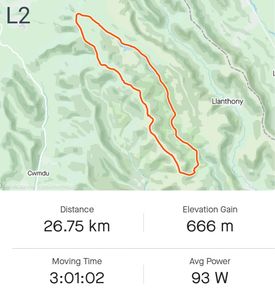
Route- follow the road up the valley, then at the Blaen Y Cwm car park take the rough track on the Right up the Right side of the valley to the Cryne Fawr Reservoir. Stop to take in the magnificent scenery, then continue of the rough and stony path to the very top of the pass.
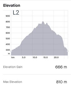
Here there is a partly paved path on the Left (give way to pedestrians). Take this to Pen Y Manllwyn, then on up to Waun Fach, then Pen Y Gadair Fawr. Drop down and find the track skirting the top of the forestry. See a path going through a gate in the forestry, then zig zag back down through the forestry to the start point.

Long off road tracks. most cyclable small amount of pushing...Stunning views
Mainly grassy tracks for much of the way. There is a steep descent through the forestry for about 1/2 mile that get steep and stoney...may need to walk the last bit, but well worth it.

Pick a fine day and you won't regret it. Many photo opportunities from the ridges.
L3 - hermitage, Pen Cerrig Calch ridge

GRADE- Moderate- a lovely gentle uphill, then a lovely ridge with a couple of steep pushes.
DISTANCE- 21 kms
HIGHLIGHTS- One of the best hill climbs ever on a gentle grassy track up a gorgeous valley. Amazing views from the ridge. A wonderful grassy descent.
START POINT- where the tarmac road ends just past the Hermitage in the Grwyne Fechan valley directly North of Crickhowell.

At the point where the tarmac road finishes there is a T Junction on gravel roads. Take the Left track and continue on this through a gate, through a field, over a stone bridge (Tal Y Maes Bridge) , and up the Left side of the valley. This is known as McManara’s road, and is one of the finest hill climbs we have ever found. There is a lovely grassy track up a spectacular steep sided valley. Near the top there is a hairpin pin heading up to the Col. Here there is a grassy track on the Left, leading up to Mynydd Llysia, with spectacular views in all directions.

Continue on to Pen Allt Mawr, where there is a short steep push to the top. From here there is a newly surfaced trail to Pen Gloch Y Pibwr, where you will find one of the finest views in Wales. The path to Pen Cerrig Calch is either challenging, or great fun- depending on your perspective, due to irregular rocks all the way. From the summit there is a path straight ahead which starts off rocky, but soon becomes a wonderful grassy descent all the way to Table Mountain. It is worth leaving your bike here and climbing the last 20 metres to the summit to enjoy further spectacular views.
You need to double back up the grassy path you came down for about 100 yards then take the grassy path going off at an angle on your Right. This leads down to a gate, which takes you onto a steep lane leading down to Graig Lwyd , then green cottage. From here take the road back to the Hermitage.

view down the first long grassy climb
View along the ridge from the highest point. some short climbs a steep
L4 - hermitage, Twyn Talycefn ridge.

GRADE- Hard- a long uphill , steep in places, then a lovely long ridge.
DISTANCE-40 kms
HIGHLIGHTS- One of the best rides we have ever done. Amazing views from the ridges.
START POINT- where the tarmac road ends just past the Hermitage in the Grwyne Fechan valley directly North of Crickhowell.

At the point where the tarmac road finishes there is a T Junction on gravel roads. Take the Left track and continue on this through a gate, through a field, over a stone bridge (Tal Y Maes Bridge) , and up the Left side of the valley. This is known as McManara’s road, and is one of the finest hill climbs we have ever found. There is a lovely grassy track up a spectacular steep sided valley. Near the top there is a hairpin pin heading up to the Col. At the top head Right toward Pen Trumau. There is a short steep section which you will need to walk. .

From this summit there is a lovely ridge leading up to Waun Fach. From here drop down the hill Left towards Pen-Y -Man Llwyn and onward down to the main track (coming up from Grwyne Fawr Resevoir). Go straight across this track to the Trig point on Rhos Dirion. Here take the track on the Right towards Twyn Tal Cefn. Beware of pinch punctures on the stone gullies! Continue along the most magnificent ridge you can imagine to Blacksmith's anvil, then a fantastic long gradual grassy descent until you get to a gate. Just after the gate take the fork Right, and continue along the lovely stone wall until it enters an old lane

Continue down this until it joins a minor farm road, at New Inn farm. Follow this down to the Cross Roads by the phone box. Take the road opposite in the direction of LLangenny. After a mile this comes to a cross roads with an old gravelly lane on your right. Take this to the farm at Gudder, then turn right up the hill on the road to Milaid Isaf and Blaenau Isaf. It eventually joins the road heading back to the Hermitage.

View along the ridge from the highest point. some short climbs a steep
L5 -around sugar loaf

HARD- SHort but sweet! Some steep challenging off road climbs.
DISTANCE- 16.5 kms
HIGHLIGHTS- This is one of the most iconic and scenic mountains in South Wales. From most angles it looks impossible to cycle, but there is a steep path up one shoulder, which makes it possible
START POINT. car park on Mynydd Llanwenarth, a mile directly South of the summit of Sugarloaf.

ROUTE- From the upper car park where the road finishes, there is a rutted track leading Left around Mynydd Llanwenarth. Keep following the grassy tracks West, then drop down into a steep valley and back up the other side. Continue around the base of Mynydd Pen Y Fal on a farm track until just before Gob Pwllau where you see a steep path leading up onto the ridge of Mynydd Pen Y Fal. Even on an ebike this means a short steep push of about 80 yards.

There are then some lovely wide grassy trails leading to the summit of Sugar loaf. the last 50 yards involves another push to the Trig Point at the summit, where you enjoy the most wonderful views. You need to back track along the trail you came up around the base of the summit then follow the track around the North of the summit and keep circling until you pick up the trail to Twyn Gwyn.

Here turn Left along a narrow path and skirt the forestry to the North of Parc Lodge Farm. Keep on the ridge towards Deri, but watch out for a path dropping down through the next patch of forest until you get to Sunny View. Here there is a gate on your right which leads down through the forest to a road.Turn Left down to Porth Y Parc, then follow the road around Llwyn Du and climb back up to St Mary's Vale. Follow this half way up and take a turn Left into Pen Yr Heol, then follow the road up the hill back to the car park.

great long speedy descent form sugar loaf in the distance
L6 -Bwlch, Mynydd Llangorse, Dinas castle

GRADE- Hard- a long ride with several long hill climbs off road.
Distance- 35kms
HIGHLIGHTS -one of the best rides ever- iconic scenery with some wonderful grassy trails across the ridges.
START POINT- Bwlch, on the A40T between Crickhowell and Brecon

ROUTE-In Bwlch take the minor road to Tremynfa. 200 yards along this road is a small car park (for 6 cars). Opposite this is the start of a track leading to a long climb up onto Cefn Moel, then along some wonderful grassy tracks over Mynydd Llangorse. Just after the summit there is a track on the right which takes you back over Pen Tir. Here you will find a small pond with a track leading down a steep path into Cwm Sorgum. As you get ot the first field, take the track Left and follow the fence line up the valley until it joins the road at Cockit Hill.

- Take the road all the way down Cwm Sorgum valley to the main A479 road. Cross over to Blaunau Mawr and find a bridle way to Glan Y Nant, and on up the valley to Glandwr. At Tyisha take the bridle way Right, then the road around the back of Dinas castle, and another bridleway leading up to the top of the col. Here you can leave your bike and take a short walk to the top of Dinas Castle where you will find fascinating ruins and incredible views.
- Continue on the track around the hill until it joins the road going to Pengenffordd. Cross the main road again and follow the tracks along the base of Mynydd Troed until you get to Cockitt Hill. Cross the road and follow the tracks skirting the base of Mynydd Llangorse until you get to Cwm Shenkin. Here there is a footpath on the Left leading up a steep hill which takes you back onto Cefn Moel where you can retrace your steps back to the car.
Stunning views... well worth the climb.
Long grassy riding.
L7 -Crug Mawr, & Twyn Y Gaer

GRADE- Hard- a good ride with two long hill climbs
Distance: 33k
Ascent: 940m
HIGHLIGHTS - some lovely trails over wonderful ridges.
START POINT- Lay-by on minor road N of Crickhowell by turn off to Llanbedr SO 234203.

ROUTE- In Llanbedr go SA past church onto track downhill. Cross bridge and head along river bank to meet lane at Gudder Farm. Just R of farm access road take byway SA for 2k to meet tarmac lane. Go L and in 1k R at fork to reach 5-way junction at Pontyspig.

- Go SA uphill on narrow lane and just below Neuadd Farm take second R onto byway below Gaer Farm. In 1k, just after passing below house go L uphill and L again at T-junction to reach the common. Go L and around base of Iron Age fort of Twyn-y-Gaer.

- From top go N onto byway above Llanthony Wood and follow this for around 2k. Just before field enclosure bear half L onto FP then take L fork downhill to muddy field corner. Cross Nant Brân and go L through gate onto byway which leads down to Pont Cadwgan car park.
. Go R on valley road and in 1.5k go L onto forestry track. Follow zig zags up Mynydd Du Forest to reach T-junction at the top. Go R toward Blaen Nant-y-Bedd and in 1k look for narrow path half L which leads onto ridge of Pen Twyn Mawr. Go L and follow single track to Crug Mawr summit. Just beyond summit drop down half R onto sheep track. Just after re-joining main path detour half L onto Blaen yr Henbant. Back on main path descend to gate and go SA on bridleway to join tarmac lane at Henbant-fawr Farm. Follow lane down to Gudder Farm then re-trace outward route back to start.
L8 -Sugar Loaf circuit

GRADE- Hard- a challenging ride with two long hill climbs on grass, but well worth the effort!
Distance: 20k
Ascent: 790m
HIGHLIGHTS - some lovely trails over and around an iconic mountain. One of our best rides on the site!
START POINT- Abergavenny, lay-by at the top end of Chapel Street near Porth y Parc Farm (NP7 7HU, ///positions.retail.support).

ROUTE- Head back downhill for 700m and turn L by service reservoir. Cross ford, go uphill on track and L at top by Sunny Vale. In 100m at sharp L bend look out for small path on R and take this. Keep SA for 1.5k contouring below Y Deri. At T-junction with tarmac lane go L steeply uphill. In 400m, go R by garage and in 1k, at Triley Court, go L steeply uphill. Climb shoulder of hill for 1k with great views E to Ysgyryd Fawr. At track summit, opposite wall corner, go L on path through bracken and ascend to top of ridge and amazing view of Sugar Loaf summit.

- Go SA across ridge path aiming for field gate 100m ahead. Just before gate go R on path alongside fence which leads to lovely singletrack through old oak wood. At far side of wood by gate with National Trust sign go half R and after 500m go L on clear ascending path. At T-junction go R and contour beneath summit to top of Mynydd Pen-y-Fal ridge.
- Detour to visit summit then go down ridge on grassy path and at end of ridge take L fork steeply downhill. At the bottom go L by fence and, in 400m, just above stream crossing go R on muddy bridleway. Cross three fields then go L downhill on stony path along line of trees to meet farm track. Go sharp L downhill to ford then uphill past Cwm-cegyr Farm and, where track levels, L past Pen-y-Graig Farm to reach Llanwenarth car park.
Take grassy path on L and follow for 1.5k bearing R toward Sugar Loaf summit. About 300m after path starts to ascend go R on contouring path toward Twyn Gwyn. Just after stream crossing go R then R again in 400m at fork. Follow lovely singletrack all the way down through woods into St Mary Vale. At bottom go R after gate then L onto tarmac lane. Just past Tyrewen Farm, at T-junction, go L uphill for 600m back to start.
Generate excitement
What's something exciting your business offers? Say it here.
L9 -Twmpa and Hay Bluff

GRADE- Hard- a challenging ride with three big hill climbs on grass, ending in a push each time, but well worth the effort!
Distance: 26k
Ascent: 840m
HIGHLIGHTS - Amazing views and some lovely trails over and around a stunning mountain. Another of our best rides on the site!
START POINT- Glasbury village car park (SO 178393, ///veered.ruling.bombshell).

ROUTE- Cross River Wye, go R onto A438 then immediately L up lane under railway bridge. Follow lane for 3k to Felindre. Cross road at staggered junction and SA for 500m then go L on bridleway alongside Felindre Brook. Go through Maes-y-lade Outdoor Centre and follow driveway to road.
- Go R and in 1.2k at sharp R bend go SA on broad grass path to base of escarpment. The way ahead is a long zig zag first L then R steeply uphill. The last quarter requires some heavy lifting on a very rocky path before finallly attaining the ridge!
- Go L and climb to Twmpa summit then take L hand gravel path for some lovely singletrack down to Gospel Pass. Next up is Hay Bluff, a steep climb on grass then a lovely ride along the escarpment. From the trig go SE for 800m then go sharp L by a marker stone onto Offa’s Dyke Path. Follow the singletrack for 2k down to the road and turn L. By the car park go R downhill for 1.5k then take the bridleway R.
Follow this for 2.5k and cross the Digedi Brook several times until reaching tarmac. Go SA for 1k then L at the T-junction and R in 200m to pass Llwynmaddy Farm and reach Fforddlas. Go L at T-junction onto NCN 42 then go R at crossroads and R again onto NCN 8. At next crossroads go L and follow lane downhill back to Glasbury.
The view looking back up at Hay Bluff!
L10 -Talgarth and Northern edge of Black Mountains.

GRADE- Hard- Lots of muddy and stony lanes, but great fun!
Distance: 30k
Ascent: 750m
HIGHLIGHTS -Some lovely views, and some good grassy paths.
START POINT Talgarth free town car park (LD3 0PE, SO 153337, ///strikers.allowable.tutorial)
ROUTE-
Go L out of car park then second R onto Bell Street and R after 250m onto Penbont Road. Continue uphill for 2.5k then go L past Pentwyn Farm and R by an old chapel to reach open hillside in 1.5k. Go SA through bridleway gate then L onto muddy contouring path about 100m above the fence line. Cross numerous stream gullies until reaching byway below Y Das.
Go L downhill on byway then R on reaching Rhos Fach to drop down to farm gate. Briefly join Three Rivers Ride taking short cut R across Rhos Fawr past a pond to reach tarmac lane. Go R past Blaenau Isaf Farm then R again in 1.5k onto a byway that leads to open hillside below Rhiw y Fan. After 500m, below Rhiw Wen, go L on byway downhill between fields.
Just before farm gate double back R on stony track to cross valley via dipping pool.
At far side of valley go L on bridleway to join tarmac in 700m. Follow lane downhill and go L at crossroads towards Felindre.
In village go L, then L again, then R onto narrow tarmac lane steeply uphill past Dan-y-Common to Common Bychan. Go R on byway for 800m then sharply L uphill, initially over rocks, to reach tarmac. Go SA steeply downhill to Llanelieu then SA uphill past church to Rhos Fach.
Go R along lower edge of common, R on reaching tarmac then L on byway past Berth Fedw Farm down to Pwll-y-Wrach. Turn R and follow tarmac lane downhill for 2.5k back to Talgarth.
L11 -Llangorse circuit

GRADE-Medium- One or two medium climbs off road. Mostly good tracks, with some lanes. .
Distance: 38k
Ascent: 990m
HIGHLIGHTS -Some lovely views, and some good grassy paths.
START POINT Llangors Common car park (SO 129272, ///escape.powder.rucksack).
ROUTE-
Follow road to Llanfihangel Tal-y-Llyn, pass church on R then take second lane on L to Tal-y-Llyn. At T-junction go R and in 300m, at sharp bend, go L through farm gate onto Three Rivers Ride. This is ‘nettle alley’ a singletrack that gets overgrown in summer. Pass through multiple gates over Pen-y-Commin and drop down to lane. Go L toward Pennorth. In 700m just after passing church go R onto bridleway, another ‘nettle alley’ but without gates
In 1k reach junction with dirt track and go R uphill on stony track to summit of Allt-yr-Esgair. To descend go SA then bear R at fork and drop down to gate. Beyond gate enjoy almost 1.5k of fast singletrack on enclosed lane to reach road.
At road go L then R at T-junction and L along green alley next to cottage onto B4560. Go L for 100m then R on byway up past Heol Las Farm.
Halfway up hillside at farm gate go R uphill on bridleway onto Mynydd Llangorse. Go L on grassy paths to trig point at 506m. Keep SA to the fort just before the end of the ridge. Drop down R and follow winding path down to road. Go L then immediately R onto muddy bridleway down Cwm Sorgwm. At tarmac lane go L past Blaenau-draw Farm to valley road then R to reach A479.
Go R then immediately L on bridleway past cottages. Continue SA across lane, bear R on bridleway up to Penyrheol then L on tarmac lane. In 1k reach crossroads where there is a choice of onward route. Go SA to follow byway along valley bottom for 2.5k or go R on quiet lane to Cwm Fforest Farm. About 250m past farm go R on byway across ford to Panteg which leads to cycle path along A479. Just after crossing side road the path ends.
Cross road and take narrow bridleway to L of old chapel which leads to lane just above Whitelow Farm. Go L and in 800m, at sharp L bend, go R on byway down to Heol-y-Cefn. Go L on lane then L again in 1k on bridleway through Crickie Farm back to Llangors. Go L through village, R just before church and then L just after school back onto Llangors Common.
L12 -Felinfach circuit
GRADE-Medium- Lots of good tracks across grassy commons, some tricky lanes.
Distance: 35k
Ascent: 850m
HIGHLIGHTS -Some lovely views, and some good grassy paths.
START POINT Start: Gravel lay-by in Felinfach village (SO 090331, ///tunnel.hunk.pinks).
ROUTE-
From lay-by go L uphill on lane by Plough and Harrow and in 300m go R uphill to Trawscoed Farm. Keep SA for 4k crossing first area of common then, just beyond Pentrenewbury Farm, go R on track onto common. Drop down R and through farm gate onto byway toward Goetre. After 2k this comes out on lane opposite Tynewydd Farm. Go R downhill to Ponde, then L at T-junction. Follow road for 2k to the top of the common and go R on track to Nant-yr-Arian Farm. Where track bends R keep SA and head for obvious summit of Mynydd Ffrorest
From here there are amazing views of the whole Bannau Brycheiniog N escarpment.
From the trig descend SE going R at fork in 150m then keep R over Brechfa Common to meet tarmac lane. Go R to Brechfa Pool for more great views. Go R by red phone box and at Maesgwyn Farm go R through gate then immediately L onto narrow stony byway back down to Ponde. At bottom go L then R uphill then L at fork toward Cilfodig Farm. Beyond farm keep SA on byway onto common and go R in 500m at track junction. Make sure to follow green path through bracken along crest of hill and don’t drop down L.
Soon after path starts to descend meet junction of paths and go half L then half L again (due S) in 250m. Go through gate onto short byway leading to lane near Penywern Farm. Go R downhill for 1k to T-junction, then L, R, L and R again past Tredurn Farm to reach A470.
Go R and in 500m, at busy T-junction, go SA on lane across Dulas Vallley and up to Llanfilo village. At entrance to village look out for byway on R marked ‘not suitable for motor vehicles’. Follow this for 2.5k, initially on tarmac then overgrown path, to meet lane at Lower Tylecrwn Farm.
Go R downhill to A470, cross it (with care) and go SA into farm drive and through gate adjacent to farmhouse onto bridleway. Go SA across two fields then sharp R just before gate to follow sunken track via bottom L of field onto lane. Go R uphill then R at T-junction to Talachddu then 1k downhill back to start
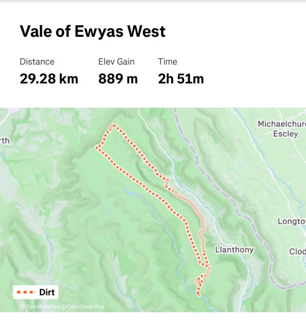
L13 -Vale of Ewyas
GRADE-Medium- two medium challenging climbs. mostly grassy tracks.
Distance: 30k
Ascent: 890m
HIGHLIGHTS -Some lovely views over the Black mountains, and some good grassy paths.
START POINT Pont Cadwgan car park in Grwyne Fawr Valley (SO 267251, ///revise.tastes.paddlers).
ROUTE-
Head back to car park entrance and take forestry track uphill on R. After sharp L bend meet T-junction and go L. In 250m take grassy track sharp R, past a house in a clearing and through a gate onto open hillside. Go R and in 100m look for path on L through clump of hawthorn trees.
Follow this uphill for 500m to reach cairn at Bâl Bach. Go L and in 50m go R on narrow grass path into Vale of Ewyas. This contours around hillside before dropping down to field boundary in 2k and passing through a pair of gates. Follow this for another 2.5k keeping above field boundary to reach a large hollow in the hillside. 500m beyond this cross large stream and drop down R to emerge at The Grange in Capel-y-Ff
At road go L for 2k and through a series of gates to reach singletrack heading up to the valley head. This is rocky in a couple of places but eventually leads to the N escarpment below Twmpa. Go L and follow good path to the trig on Pen Rhos Dirion.
Go L on good singletrack along an epic ridge for 8k over Twyn Talycefn, Chwarel y Fan and Bâl Mawr to arrive back at cairn on Bâl Bach. Return to car park via the outward route.