- Home
- Overview
- About Us
- Routes
- A-Around Blaenavon Routes
- B- Gwent Valley Routes
- C-Around Abercarm
- D- North of Pontyrpidd
- E- South of Pontypridd
- F- West of Pontypridd
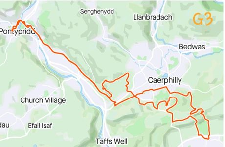
- G- Around Caerphilly
- H- Around Merthyr
- J- Bwlch & Rhigos Routes
- K- Neath & Glyncorrwg
- L-Black Mountains
- M- Llantrisant and Vale
- N- Port Talbot & Swansea
- O- Brecon Beacons
- P- West Wales
- Q- Mid Wales
- R- around Llandovery
- S- Mynydd Epynt
- T- Train and Bike
- U- Welsh Borders.
G1- Caerphilly mountain, Ruperra Castle, Machen

Grade- moderate- undulating forest and mountain tracks, with a short climb uphill at the end.
Distance- 26KM
Highlights- Some lovely woodland paths on Caerphilly mountain. The ruins of Ruperra Castle and hillfort.
Start point- cafe on top of Caerphilly mountain

Route- from the far left corner of the car park is a wonderful muddy path that drops down through the woods, then climbs back up again to the ridge. Follow the ridge East , crossing a small road, then continue straight on until you arrive at the Maenllwyd Inn.

Here at the crossroads, take a turn Right down a small hill and back up the other side. At the next cross roads, take the track on the Left and follow this to Ruperra Castle.

This is a wonderful old ruin. Trails on the Left lead up to a pretty viewpoint on the top of a hill, before dropping back down through the woods to the road into Draethen. Take the lane on the Left leading into Machen .

. From here you can find the family bike trail leading into Bedwas and back to Caerphilly. If you have parked in the cafe , there is the final sting in the tail of having to climb back up Caerphilly common to the start point.
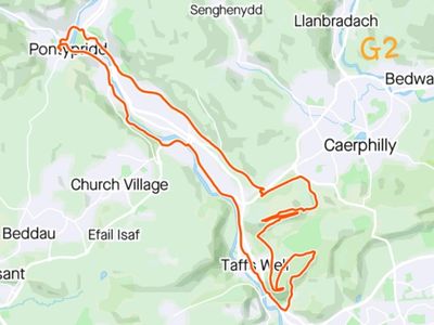
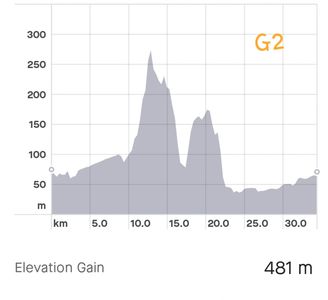
G2- Caerphilly Ridgeway,
Grade- Fairly easy. This is a good introduction to mountain biking. It is quite a short route, with just one steep climb, which can be walked.
Distance- 26.7kms
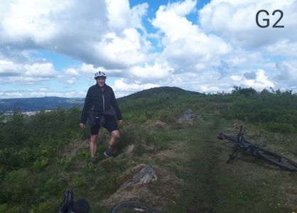
Highlights- a short but spectacular ridge. The views up and down the Taff valley are stupendous.
Start point- Taff Trail at Glyntaff Cemetery. For a shorter ride this can be started by the traffic lights on Nantgarw hill where the Taff Trail crosses the dual carriageway.
Route- follow the Taff Trail to Nantagrw. Just after crossing the dual carriageway take the trail up the hill to the Left towards Caerphilly. When you come to the main road turn Right and after 200 yards turn up the lane on the Right. Take the second lane on the right, and after 600 yards find a gate on the right. Follow this up a zigzagging gravel path to the top of the hill, then follow the ridge to the final view point.
This provides the most spectacular views up and down the Taff valley.
Double back on your tracks for 200 yards and find a trail winding down the South side. There are several tracks here which end in footpaths through the bushes back onto the Taff Trail. For a shorter ride turn Right back to Caerphilly. Otherwise turn Left and drop down into Taff's Well. Here pick up another lovely bike trail which leads back to Treforest Trading Estate. At the roundabout at the far end take the road up to Tescos and just after the small roundabout find a path back up to the Taff Trail.

Caerphilly Ridgeway with the Garth in the distance.
Please stick to the path since there are some rare birds nesting here.
Caerphilly Ridgeway from Caerphilly mountain.
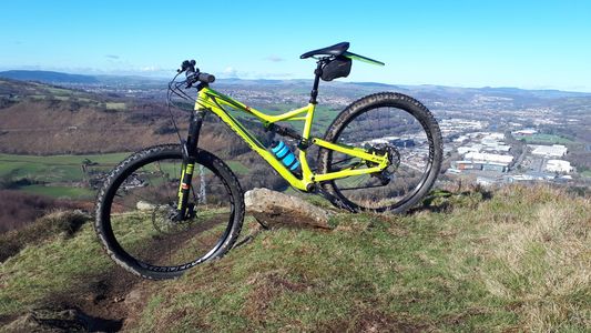
Caerphilly Ridgeway with the flat top tip in Blaenllechau.
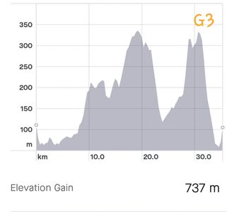
G3- Pontypridd, Caerphilly to Cefn On park and back.
Grade- hard- a long gentle climb initially, a tricky muddy descent into Lisvane, then a challenging off road climb out of Cefn On.
Distance-41 kms
Highlights- The challenging descents and climbs back up are exhilarating.
Start point- Taff trail in Pontypridd heading South.
For a shorter ride this can be started at Castle Coch, or from the mountain road from Caerphilly to Cardiff.
Route-We followed the Taff Trail South from Pontypridd. Just after Nantgarw hill there is a turning on the Left on the cylcle path up to Caephilly. Keep going until you come to a lane, turn right, then after a few hundred yards turn Left down a lane which is signposted as a dead end. Follow this up the hill and come out on the main road between Caerphilly and Cardiff. A few hundred yards up the hill there is a small lane with a single track path on the Left
. This gives wonderful views over Caerphilly. At a junction take the footpath down towards the Golf course, then cross the road and find a lovely track through the woods which winds it's way back the cafe on the top of Caerphiily hill. Take the main road towards Cardiff, and at the bottom of the dip, just before the Traveler's Rest Inn, find a lane on the Left. Take this uphill until you come to a T junction with another track.
Turn Right down an old lane, which is very muddy in the winter. This heads steeply down a lane, which is either terrifying, or great fun- depending on your skill levels. This brings you onto the main road into Lisvane. Turn Left here towards Cefn On Park and go through the car park. Just before the entrance gate into the main park, there is a lane on the Right, which skirts the main park then climbs steadily up a challenging hill for about a mile. This brings you back onto the ridge overlooking Bedwas.
From here we turned Left down the hill into the woods, where there is a maze of paths. We took a route which crosses Caerphilly , back to the roundabout at the top of Nantgarw hill then took the lane behind the garden centre. On the Right is a lane named Gypsy Lane" which takes you up a hill to a T junction. Turn Left along Groes Wen lane, then at the next junction there are a myriad of lovely trails across the old nantgarw caol tip, which eventually drop back down onto the Taff Trail.
some of forestry paths are beautiful.
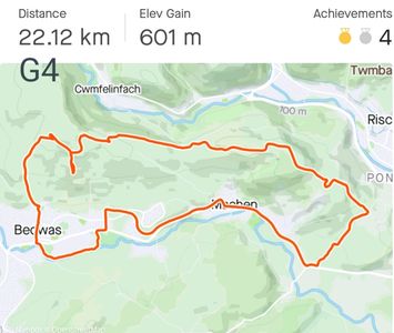
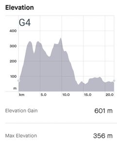
G4- Bedwas, Machen tips
Grade- hard- a fairly short ride, but a long steep climb to start, followed by undulating paths over the tips.
Distance-22.1KM
Highlights- Great views from both Bedwas and Machen tips.
Start point- the main street in Bedwas.
Route- follow the main street in Bedwas straight ahead. It starts to climb a steep hill on tarmac initially, which turns into an even steeper climb on a gravel road. Follow this upwards, then find a track on the right leading up to the foot of the coal tips. Follow this track along the base of the tip until the tip ends and the track turns Left over the ridge.
Take the tracks to the Right, then when you come to the start of a tarmac road , drop down to the left on a steep muddy bank, and join a lovely gravel lane which gently drops down for about a mile until it gets to a minor road.
As you join this road there is a gravel track on the right leading up the old coal tip above Machen. Turn Left, taking tacks running along the base of the coal tip, then at the end of the tips, find a track leading up to the TV mast on the next ridge. Here there are tracks going off in all directions.
Follow the track straight ahead, down a steep rutted track, keep going straight ahead until you come to a gravel lane, then on through the woods until arriving at a small road heading back into Machen Uchaf. From Machen there is a lovely family bike trail back into Bedwas.
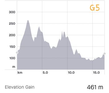
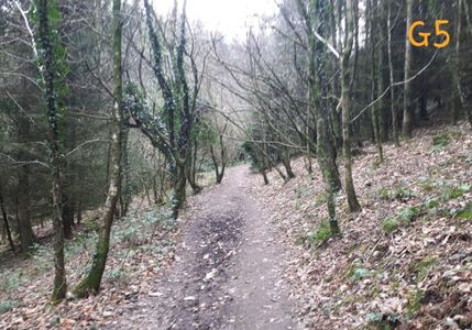
G5 Caerphilly skills park and mountain.
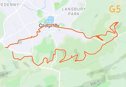
Grade- moderate- a few medium climbs, with lots of muddy off road.
Distance-17.5kms
Highlights- . some great views off Rudry mountain. Play around the bumps and berms in the skills park.
Start point- the bike trail up to Caerphilly from the Taff Trail
Route - just after the traffic lights, where the Taff Trail crosses the dual carriageway heading up to Caerphilly, there is a bike trail Left going up the hill parallel to the main road. Follow this up and across until it joins a small road. Turn Right, and after 200 yards take the first turn Left down a little hill, then continue past the "dead end" signs up hill until you get to the main bypass road around Caerphilly. Turn Right up this for 400 yards, then take a track Left across Caerphilly common. There are loads of tracks across this, so wind your way across onto Van Hill where you can pick up a track heading into the large woodland South of Caerphilly. There are a myriad of wonderful bike trails running through this extensive woodland.
We ended up following a good track which turned into a footpath, and ended up pushing our bikes for half a mile, so please feel free to make your own trails , rather than following ours. Aim to come out on Rudry Hill. There are lovely views from the top, and good trails circumnavigating the hill. Take one of several paths West leading into Coed Parc-y-fan. Here you will find a skills park with a dozen short circuits of bumps and berms to play on. We then took the road into Caerphilly town centre, through the castle grounds and back to the start point.
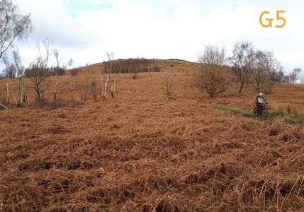
through the bracken on Rudry Hill.
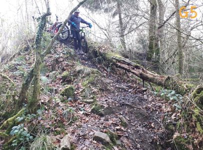
Some walking.... but you don't need to do this .part if you find your own trails!!
back on the fast paths.
G6 Caerphilly woods, Rudry woods, Machen forest.
Grade- hard- a long gentle climb to start, , with lots of muddy off road.
Distance-48kms
Highlights- . some great views over Cardiff. from Caerphilly mountain.
Start point- Taff Trail South from Pontypridd
Route -Follow the Taff Trail South from Pontypridd. Halfway between Treforest trading estate and nantgarw Hill, there is a track on the Left, which goes up a very steep gravel track onto the old Nangarw Coal tips. Here you will find a multitude of great tracks, lines by Gorse. Zig zag up these to the top and pick up a lane heading towards Groes Wen.
. Just after Groes Wen take a lane on the Right (Known as Gypsy Lane) and then at the T junction tunr Left onto the roundabout at the top of Nangarw hill. Take the exit for the bypass heading towards Cardiff. 200 yards on the Right you come to a country lane. Turn up this lane for 200 yards, then take the dead end road on the Left, down a dip, up a hill (past the dead end sign) and keep going until you cross the main road.
On the other side pick up tracks that lead over Caerphilly mountain and drop down past the golf course. Come out on the hill out of the town centre. On the other side is a track into Caerphilly woods.
Here there is a wonderful maze of trails in all directions. We worked our way up onto the ridge and then followed it Left towards Rudry. Keeping to the South side of the ridge gives great views over Cardiff, and ends up in some great (muddy) single track, before coming out at the Maen Llwyd pub. Follow the lane from the back of this pub and take a path into Machen woods.
Here you will find an almost endless maze of single tracks running between the forest roads. We made our way back to the Maen Llwyd, then took the lane in the direction of Caerphilly. At the car park by the Lime Kilns on the Left, we took a path back through Caerphilly woods, which then takes you onto a bike trail running through the heart of Caerphilly and back to the start point.
G7 Machen Circuit.

Grade- moderate
Highlights- Mainly good forest tracks. Good views
Start point- Car Park outside village hall in The Crescent.
Route- exit the car park and cross the bridge and up Green Row. Turn Right into Tudor gardens. At the end of the road there is a challenging single track. Follow this up to a forest track and turn Right. Continue straight ahead all the way to the top and come out in the car park just before the Maen Llwyd Inn. Take the road Left down the hill opposite the hill, then climb back up to a cross roads
Take the Left turn along a dirt track road. Pass the burnt out Ruperra castle and continue until you come to a tarmac lane. Turn Left and continue to Draethen, then turn Right until you get to the main A468 road. Go straight across into Lower Machen, then continue upwards along Upper Ochrwyth Lane until you come to a cross roads.
Take the Left hand turn and continue straight ahead where the lane becomes dirt track. Keep going straight until you see the final steep climb up to Machen Mountain. At the top of the climb is a bench in front of the Trig point. To the Left of the bench is a single track going down hill into Machen. At the firs junction take the Left fork and continue straight down hill until you see a major track on your right.
Some Follow this along the contours, overlooking Machen, keeping machen Tip on your Right. Eventually you cross over the ridge and come to a locked gate. Just after the gate is a bridle way which heads back to Machen and eventually joins Penrhiw Lane which takes you downhill back to the centre of Machen.